Tarset with Greystead Parish extends over a total area of some 73 square miles of rugged countryside combining the two original separate parishes (of 166 in Northumberland), now wards. Tarset Civil Parish (CP) and Greystead CP are in Tynedale, Northumberland in North East England, largely within the Northumberland National Park. Much of the parish is within the international dark skies park. The area is famous for its hill lamb and reiver history, including some of the best preserved bastles in the UK.
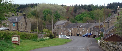
The sparse population lives in isolated dwellings and farmhouses across the fells and commons with two hamlets at Lanehead and Greenhaugh.
The fells are dotted with the former industry of the area in the form of medieval stone pits, lime kilns and 19th & 20 century quarries. The economy today revolves around farming and tourism, the area is large and peaceful and ideal for the “getaway” holiday. The ward of Greystead is mainly laid to productive forest.
The fells also indicate the turbulent past of the area. There is the ruined Tarset castle, there are old bastles (defensible farmsteads) including the Black Middens Bastle House just north of Greenhaugh. The pele towers (defensible houses) and many other ruins date back to the 15th & 16th centuries. Those defensible houses grew out of the rise of the raids of the Reivers, the lawless families that roamed the border areas. Some reiver surnames are still common in the area today like Armstrong, Charlton, Dodd, Elliott, Hetherington, Milburn, Robson.
See these other sections of this website:
Tarset with Greystead Parish has a combined population of around 290, located in almost 160 households. The Office for National Statistics' website also has maps of Tarset CP and Greystead CP in Tynedale non-metropolitan district. Note these are different to the Church of England parish boundaries (of Bellingham, and Falstone with Greystead & Thorneyburn). Historical information is linked from the main community page.
Council tax is collected by Northumberland County Council. Summary data from the 2011 census is published (Tarset census fact sheet) on the county website (there is also a separate factsheet for Greystead, but it contains the same data as the factsheet for Tarset). There is also a whole Northumberland census fact sheet.
The parish council has their own website which includes meeting notices, agenda and minutes, councillor names, roles and contact details, and other documents and notices:
https://www.tarsetandgreysteadpc.org
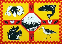
The parish flag was selected by competition. The successful design was created by Margaret Bird.
See also the past work of the Neighbourhood Planning Group.
Northumberland County Council's website lists all parish and town councils. There is a separate map showing the parish boundaries in 2024.
Tarset is located within the UK Parliament constituency of Hexham.